Laguna Garzon: The Circular Bridge & the Lagoon Coast (2026)
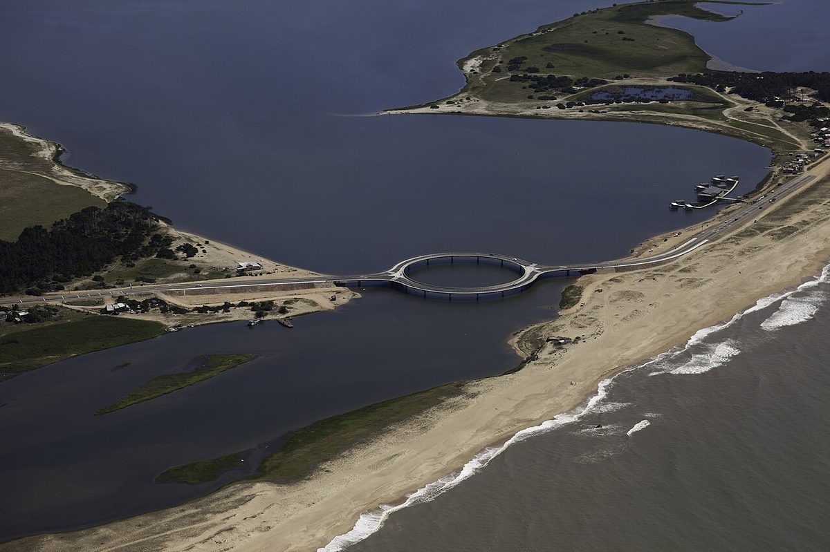
The first time I drove the Puente Laguna Garzón I nearly missed the turn for it, which felt absurd afterward, because there is no road in this part of Uruguay you are less likely to forget. The Laguna Garzon bridge is the reason: a perfect ring of road laid flat across the water. Ruta 10 runs east out of José Ignacio as a thin grey ribbon between the dunes and the scrub, and then the asphalt simply curves away from you and becomes a circle laid flat across the water. You slow down. You have no choice. The car leans into the ring, the lagoon opens out on both sides, and for about thirty seconds you are driving in a shape that has no business being a bridge at all.
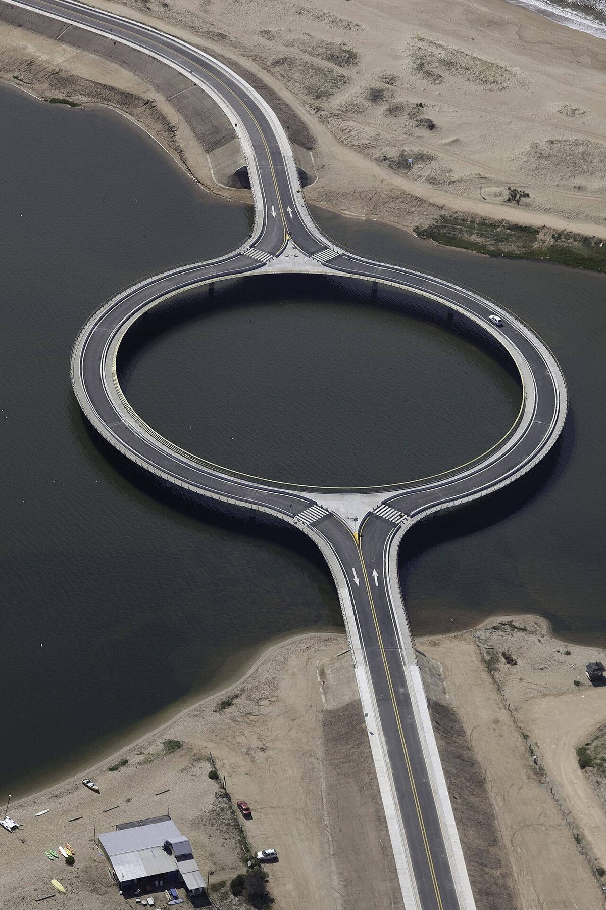
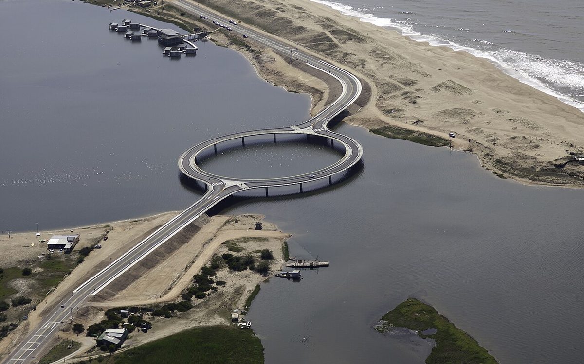
Here is the short version. The laguna garzon bridge is a circular, one-way ring road that carries Ruta 10 across the Laguna Garzón between Uruguay’s Maldonado and Rocha departments. Designed by the Uruguayan architect Rafael Viñoly and opened in December 2015, its 202-metre ring forces drivers to slow down, frames the view of the lagoon, and replaced the old vehicle raft that used to ferry cars across two at a time.
What this guide covers
This is a guide to the bridge and the quiet lagoon coast on either side of it — the western edge of the Rocha department, where the wetlands start and the crowds of Punta del Este finally thin out. I’ll walk you through the circular bridge itself: why Viñoly drew a ring instead of a straight span, the money and the arguments behind it, and exactly how you drive across it today. Then I’ll head east into the lagoons, because the bridge is really a doorway into a stretch of coast that most visitors blow straight through.
A note before we start: the Laguna Garzón (the lagoon the bridge crosses) and the Laguna de Rocha further east are two different bodies of water. People conflate them constantly. The bridge spans the first; the flamingos and the fishing hamlet I’ll describe later belong to the second. I’ll keep them straight as we go. This guide sits inside our wider guide to the Rocha department, so if you want the full sweep of the coast — Cabo Polonio, the surf towns, the national parks — start there and come back.
| At a glance | Puente Laguna Garzón |
|---|---|
| What it is | A circular (ring-shaped) road bridge carrying Ruta 10 across the Laguna Garzón |
| Where | On the Maldonado–Rocha department border, about 7 km east of the José Ignacio roundabout, roughly 40 km / 40 min from Punta del Este |
| Architect | Rafael Viñoly (Uruguayan), structural engineering by CYD Ingenieros |
| Opened | 22 December 2015 (construction began September 2014) |
| Length / form | 202 m ring, 16 concrete pillars, two one-way lanes split around the circle, inner and outer footpaths |
| Cost | ~US$10–11 million; about 80% funded privately by developer Eduardo Costantini |
| How to visit | By car, as a drive-through photo stop; free parking on the approaches; no fee, no services on the bridge itself |
| Honest catch | It’s a beautiful crossing, not a destination with cafés and toilets — bring everything you need |
The circular bridge: why Uruguay built a ring across a lagoon
For most of its history this crossing wasn’t a bridge at all. Where the Laguna Garzón meets the Atlantic, the water cuts clean through the coast and severs Ruta 10. To get a car from the Maldonado side to the Rocha side you drove onto a balsa — a small motorised raft that carried two vehicles at a time, ran only in daylight, and stopped whenever the weather turned. It was slow and charming and a genuine bottleneck. The Ministry of Transport had wanted a fixed crossing here for decades.
The obvious answer was a straight bridge, and that is exactly what the Uruguayan architect Rafael Viñoly refused to build. Viñoly — the man behind Montevideo’s Carrasco airport terminal and, less happily, London’s “Walkie-Talkie” tower — argued that a normal high-speed span would do two bad things at once: it would let traffic rip across a fragile lagoon at 90 km/h, and it would quietly turn the sleepy Rocha coast into an extension of Punta del Este’s property market. His response was a circle.
How the ring actually works
Mechanically, the design splits the road into two one-way carriageways that bow apart and meet again, forming a 202-metre ring sitting flat on the water. You enter on one side, the curve tightens, and the geometry itself forces you down to a crawl — there is no way to take a tight circular ramp at speed without ending up in the lagoon. That’s the headline trick everyone repeats: the bridge slows you down so you’ll look at the view. It works. I have never crossed it quickly, and I’ve never wanted to.
Cleverer still is the environmental logic, which rarely makes the listicles. By separating the two carriageways into a ring rather than a solid deck, the design reduces how long any single patch of water sits in continuous shadow as the sun tracks across the sky. Less continuous shade means more light reaching down through the water column, which matters in a shallow coastal lagoon where the whole food chain depends on what grows in the shallows. The ring rests on 16 round concrete pillars set about 20 metres apart, tall enough for small boats to pass underneath, and engineered with as few supports in the water as the span allowed. It is, in the architects’ phrase, a “lagoon within a lagoon” — a circle of open water held inside the road.
There are footpaths on the inner and outer edges, with marked crossings so you can switch sides, and the centre of the ring opens to the water so people can stand, fish off the rail, or just watch the light. On a calm evening it’s one of the better free shows on the coast.
The money and the argument
None of this was uncontroversial, and I think it’s worth being honest about that rather than selling the bridge as a pure feel-good story. The project cost somewhere around US$10–11 million, and roughly 80 percent of that came not from the Uruguayan state but from Eduardo Costantini, the Argentine real-estate developer behind the nearby Las Garzas resort. When a property magnate pays for most of a bridge that happens to connect his land to José Ignacio, people in Uruguay notice. Building it took 450 tonnes of steel, around 500 cubic metres of concrete and some 40,000 metres of cable.
The loudest opposition came from two directions. Conservation groups — Vida Silvestre Uruguay among them — argued the crossing was an unnecessary risk to a sensitive coastal ecosystem and that the money would have been better spent reinforcing existing inland routes. And a chunk of the José Ignacio crowd fought it on the grounds that linking the two shores would funnel traffic, development and noise into a coast they liked precisely because it was hard to reach. Some local commentators took to calling it the “puente absurdo,” the absurd bridge, for spending eight figures on a fancy circle when a plain bridge would have moved the same cars.
Set against that, the ring was arguably the price of restraint: Viñoly reportedly accepted the commission on the condition that the new bridge would mark the formal end of Ruta 10 as a through-highway, handing control of the road north to local authorities with more environmental skin in the game. And the public, for what it’s worth, was broadly in favour — surveys at the time put support at roughly 81 percent in Rocha and 64 percent in Maldonado. A decade on, the bridge is simply part of the landscape, and the property boom its critics feared has been slower and patchier than predicted.
Driving the bridge today
In practice, visiting is easy. From Punta del Este, take Ruta 10 east-northeast through La Barra and Manantiales; it’s roughly 40 kilometres and about 40 minutes to the bridge, traffic depending. From the José Ignacio roundabout you’re only about 7 kilometres away — five minutes of driving and you’re at the lagoon’s edge. Coming from the Rocha side, you’ll typically drop down off Ruta 9 onto Ruta 10 and approach from the east.
The crossing itself is free and open around the clock; the bridge is lit at night, which makes a late drive worthwhile. There’s informal free parking on the approaches if you want to get out and walk it — and you should, because the bridge is genuinely better on foot than from a moving car. Keep your speed down, watch for pedestrians on the crossings, and don’t stop dead on the carriageway for a photo; pull off and park first. One practical reality worth flagging: a standard phone camera can’t fit the whole circle in frame from ground level. The shots you’ve seen from directly overhead are drone or aircraft shots. From the ground you get the curve and the water, which is lovely, just not the full ring.
The Laguna Garzón itself
It’s easy to treat the lagoon as a backdrop for the bridge, which is a shame, because the Laguna Garzón is the reason the bridge had to be so careful in the first place. A laguna, in this part of Uruguay, isn’t a small ornamental pond — it’s a coastal lagoon, a shallow brackish basin separated from the ocean by a strip of sand, sometimes open to the sea and sometimes closed off. The Garzón covers roughly 1,800 hectares (the architects put it at about 4,448 acres) and sits right on the line between Maldonado and Rocha, half fresh water from the streams that feed it, half salt from the Atlantic.
Officially it’s classified as an Important Bird and Biodiversity Area, and you can see why: the shallows draw waders, herons, and — if you’re lucky and the season is right — small groups of Chilean flamingos picking through the mud. The water is clean enough that locals still harvest clams from the sandflats, and quiet enough that on a weekday outside summer you might have the whole shore to yourself. There are no big resorts directly on the lagoon’s edge yet, which is exactly what the conservation fight was about. The western shore feeds back toward José Ignacio; the eastern shore is the start of the long, empty Rocha coast.
Laguna de Rocha and the birdlife
Drive on east and the coast gets wilder. About 30 kilometres past the bridge — and a world away in feel — lies the Laguna de Rocha, and this is the one to remember if birds are why you came. I’ll say it once more, plainly: this is a completely separate lagoon from the Garzón. Bigger, more protected, and far richer in wildlife.
The Laguna de Rocha is a national protected area under Uruguay’s SNAP system (the national parks and protected areas network), designated a “protected landscape” of around 22,000 hectares — about 7,200 of which is open water, the rest hills, plains, wetland and a slice of the ocean shelf. Since 2015 it’s also been a Ramsar site, meaning it’s recognised internationally as a wetland that matters. More than 220 bird species have been recorded here.
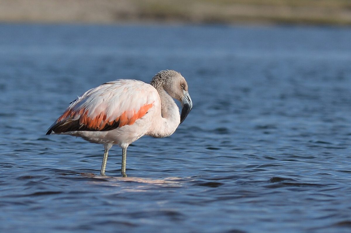
This is flamingo country in the proper sense — flocks of them filter-feeding in the shallows, alongside black-necked swans, herons, terns, and a long supporting cast of ducks and shorebirds. Spring and autumn migrations (roughly September–November and March–May) bring the biggest variety. The light is best, and the birds most active, in the first hour after dawn and the last hour before dusk; turn up at noon in January and you’ll mostly meet the wind.
The sandbar that opens to the sea
The thing that makes the Laguna de Rocha tick is its barra — the sandbar at its mouth. For long stretches the bar seals the lagoon off from the Atlantic; then, when enough water builds up behind it and the wind and waves line up, the bar breaks and the lagoon drains and mixes with the sea before slowly closing again. That rhythm of opening and closing is what keeps the water brackish, flushes nutrients, and triggers the great seasonal event of the place: the shrimp run, when shrimp that have grown buried in the lagoon bed head for the ocean and the fishing season begins. (The bar is sometimes opened artificially to spare nearby settlements from flooding, which is its own small local controversy.)
Puerto de los Botes, the fishing hamlet
On the lagoon’s edge sits Puerto de los Botes, a tiny artisanal fishing settlement where a community has worked these waters for some seventy years. They pull in shrimp, blue crab (the locals call it siri), sole, black and white croaker, and pejerrey. It is not a polished tourist village — it’s a working hamlet of boats and nets and a few weathered houses — but that’s the appeal. To reach it you turn off Ruta 9 at around kilometre 204, near the spot known as La Riviera, and head roughly 6 kilometres south down a side road toward the water. A few small operators run birdwatching and boat trips from around here, and honestly, a local guide is worth it: they know where the flamingos are standing this week and you don’t.
The lagoon coast and the José Ignacio side
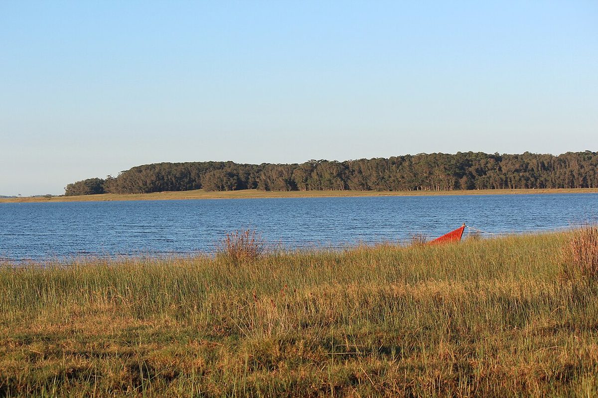
What ties all of this together is the road. Ruta 10 east of the bridge is one of the quietest, most pleasant coastal drives in Uruguay — long sandy beaches, low scrub, the occasional clutch of summer houses, and not a great deal else. Much of it is paved, though you’ll meet stretches of ripio (loose gravel road) once you wander off toward the lagoon shores; take those slowly in a low car. This is the stretch that links the José Ignacio world to the surf-town world of Rocha proper.
Just west of the bridge sits José Ignacio, the upscale anchor of this whole coast — a former fishing village turned barefoot-luxury enclave of beach houses, a lighthouse, and restaurants where dinner costs what a week’s groceries might elsewhere. I’m mentioning it rather than guiding you through it, because it sets the tone for everything to the west: polished, pricey, and lovely in January. The moment you cross the ring bridge heading east, that tone evaporates. Prices drop, services thin out, and the coast turns to the rougher, friendlier Rocha you’ll find in our guides to La Paloma and La Pedrera. Push further and you reach the car-free dunes of Cabo Polonio and the backpacker beaches of Punta del Diablo. The bridge is the hinge between those two Uruguays.
If you’re trying to place this on a map of where to go, our comparison of Punta del Este versus Rocha covers the trade-off directly: glossy and serviced to the west, raw and quiet to the east, with the lagoon coast sitting right on the seam.
How to visit: a practical plan
Here’s the unglamorous truth, and it’s the one honest drawback I’d press hardest: the bridge is mostly a drive-through photo stop, not a place you spend a day. There’s no café on it, no visitor centre, no toilet, no shop. People build whole itineraries around “the circular bridge” and arrive to find a beautiful piece of road and a parking spot. That’s fine if you know it going in. It’s a let-down if you expected an attraction with services.
So treat the bridge as one bead on a string and plan the string; our Rocha coast road trip crosses it on day one. A good half-day runs like this: leave Punta del Este or José Ignacio mid-afternoon, drive Ruta 10 to the bridge, park and walk the ring, then carry on east along the coast toward the Laguna de Rocha for the late-afternoon birdlife when the light softens. Bring water, snacks, sun cover, insect repellent (the lagoon edges can be buggy at dusk), and a windbreaker — this coast is open and the wind is real. Fuel up before you leave the towns; stations are sparse out here.
You’ll want a car — and maybe a guide
None of this works on public transport in any practical way. The lagoons sit down side roads, the timings depend on light and tide, and the distances are real. You need a vehicle. If you don’t have one, our guide to renting a car in Uruguay walks through the process, and this corridor fits neatly into a wider Uruguay road trip down the Atlantic coast. For the Laguna de Rocha specifically, consider a local birdwatching or boat guide out of the Puerto de los Botes area — they’ll get you to the wildlife you’d otherwise drive straight past, and they read the lagoon better than any app.
When to go
For the bridge alone, any time works; sunrise and sunset give the best light and the fewest cars, and the night lighting is a quiet bonus. For the birds, lean on the shoulder seasons — spring and autumn — when migration peaks and the summer crowds and heat haven’t arrived. Peak summer (December–February) is busiest and buggiest on the lagoon edges, though it’s also when José Ignacio is fully alive and the shrimp season is in swing. For a broader steer, our notes on the best time to visit Uruguay break the seasons down.
Laguna Garzon bridge: your questions answered
Why is the Laguna Garzón bridge circular?
The ring shape does two jobs. Its tight curve physically forces drivers to slow down, so they take in the lagoon instead of speeding across it. And by splitting the road into two arcs rather than one solid deck, the design reduces how long any patch of water stays shaded, letting more light reach the shallow lagoon below. Architect Rafael Viñoly designed it as a “lagoon within a lagoon.”
Who built the Laguna Garzón bridge and when?
It was designed by the Uruguayan architect Rafael Viñoly, with structural engineering by CYD Ingenieros. Construction began in September 2014 and the bridge opened on 22 December 2015, replacing a small two-car raft that had crossed the lagoon for decades. Around 80 percent of the roughly US$10–11 million cost was funded privately by the Argentine developer Eduardo Costantini.
Can you walk or cycle across the bridge?
Yes. There are footpaths on both the inner and outer edges of the ring, with marked pedestrian crossings so you can switch between them, and the centre opens to the water where people stand, fish and watch the view. Walking it is genuinely better than driving it — you actually take in the structure. Cyclists use it too. There’s free informal parking on the approaches.
Is the Laguna Garzón the same as the Laguna de Rocha?
No — they’re two different lagoons, and they get mixed up constantly. The bridge crosses the Laguna Garzón, on the Maldonado–Rocha border. The Laguna de Rocha is a larger, separately protected lagoon (a SNAP protected area and Ramsar site) lying about 30 kilometres further east, and it’s the better spot for flamingos, black-necked swans and serious birdwatching.
Is the bridge worth visiting?
If you’re already on this coast, yes — it’s a striking, free, ten-minute stop and a genuine piece of architecture. But set expectations: it’s a beautiful crossing, not a destination with cafés, toilets or shops. Pair it with the drive east along Ruta 10 and the Laguna de Rocha, and the visit makes sense. On its own, you may find it briefer than the hype suggests.
How do I get to the Laguna Garzón bridge?
By car. From Punta del Este, follow Ruta 10 east-northeast through La Barra and Manantiales — about 40 kilometres and 40 minutes. From the José Ignacio roundabout it’s only around 7 kilometres. From the Rocha side, drop down off Ruta 9 onto Ruta 10 and approach from the east. There’s no practical public-transport option, and no fuel or services at the bridge itself.
Final thoughts
I’ve crossed the Puente Laguna Garzón more times than I can count now, and the trick of it has never quite worn off — that half-second where the road stops behaving like a road and curves you out over the water. It’s a clever, stubborn, slightly show-off solution to a small problem, and it works. But the bridge’s real gift isn’t the bridge. It’s the permission it gives you to keep going east, off the edge of the José Ignacio map and into the lagoon coast, where the flamingos stand in the shallows of the Laguna de Rocha and the fishermen of Puerto de los Botes have been pulling shrimp from the same water for seventy years. Drive the ring slowly. Then don’t turn around. Keep heading north-east and, close to the Brazilian border, you reach Santa Teresa National Park, with its colonial fortress and forest campground.
Credits & sources
Sources & further reading
- Rafael Viñoly Architects — Laguna Garzón Bridge (design, facts and figures)
- Wikipedia — Laguna Garzón Bridge (history, cost, construction)
- Ministerio de Ambiente (Uruguay) — Laguna de Rocha protected area
- Turismo Rocha — Laguna de Rocha protected landscape
Photo credits
All images via Wikimedia Commons: Puente Laguna Garzon Aerial Circular by Jimmy Baikovicius from Montevideo, Uruguay (CC BY-SA 2.0); Laguna Garzon Puente Circular Vista by Jimmy Baikovicius from Montevideo, Uruguay (CC BY-SA 2.0); Laguna Garzon Lagoon Uruguay by Jimmy Baikovicius from Montevideo, Uruguay (CC BY-SA 2.0); Laguna De Rocha Flamencos Uruguay by Santifernandez2009 (CC BY-SA 3.0); Ruta 10 Rocha Coast Uruguay by Okta30 (CC BY-SA 3.0).