Uruguay National Parks: Nature, Wildlife & the Wild Coast

The first time I drove out to look for one of Uruguay’s national parks, I missed the entrance twice. There was no grand stone gateway, no ranger booth, no queue of cars — just a green sign on Route 9, a cattle grid, and a dirt track running off toward the sea. That, it turns out, is the whole personality of nature here. Uruguay does not do wilderness on a Patagonian scale, and it does not shout about what it has. You have to know where to look.
So here is the honest version. Uruguay national parks and protected areas are small, scattered, mostly uncrowded, and often free to enter — a string of coastal dunes, palm savannas, river islands, canyons and grassy hills rather than a few enormous headline reserves. Get your expectations right and they are some of the most rewarding, least-touristed corners of the country.
I have spent years driving Uruguay’s back roads, sleeping in its campgrounds and getting sand in my boots at Cabo Polonio, and this is the guide I wish I’d had: every protected area worth your time, what wildlife you’ll actually see, when to come, and how to reach places that don’t show up on most maps. It sits alongside our wider list of things to do in Uruguay, but here the focus is squarely on the wild side.
Uruguay National Parks at a Glance
There is no single “best” park because they do completely different things. One is an off-grid dune village with a sea lion colony; another is an 18th-century fort wrapped in planted forest; another is a canyon you descend into on foot. This table is how I’d match them to what you actually want from a day outdoors.
| Protected area | Region | Best for | Getting there | Entry |
|---|---|---|---|---|
| Cabo Polonio | Rocha (Atlantic coast) | Dunes, sea lions, off-grid nights, stargazing | Official 4×4 trucks from Route 10 | Park free; 4×4 ride paid |
| Santa Teresa | Rocha (Atlantic coast) | Historic fort, forest trails, camping, surf beaches | Car, Route 9 km 302 | Park free; fort small fee |
| San Miguel | Rocha (Brazilian border) | Star fort, capybaras, grassland birds, gauchos | Car, near Chuy | Free |
| Laguna de Rocha | Rocha (coastal lagoon) | Flamingos, black-necked swans, birdwatching | Car + short walk, off Route 10 | Free |
| Quebrada de los Cuervos | Treinta y Tres (interior) | Canyon hiking, native forest, viewpoints | Car, gravel road off Route 8 | Small fee |
| Cerro Arequita | Lavalleja (hills) | Short climbs, a cave, countryside views | Car, north of Minas | Small fee |
| Esteros de Farrapos | Río Negro (Río Uruguay) | Wetland birds, river islands, canoeing | Car + boat, near Nuevo Berlín | Free |
| Valle del Lunarejo | Rivera (far north) | Quiet valleys, subtropical pockets, birds | Car, gravel roads off Route 30 | Free |
Notice the pattern: almost everything needs a car, most are free, and the densest cluster sits in the wild coast of Rocha. If you only have time for one region, make it that one.
How Uruguay National Parks Actually Work (Read This First)
Here’s where most English-language articles fall apart — they can’t agree on how many national parks Uruguay even has. I’ve seen “four,” “seventeen” and “twenty-nine” all stated as fact on page one of Google. The confusion is understandable, because Uruguay’s system doesn’t map neatly onto the North American idea of a “National Park.”
The country’s protected areas are governed by a single framework called SNAP — the Sistema Nacional de Áreas Protegidas (National System of Protected Areas), created by Law 17,234 in 2000 and run today by the Ministry of Environment. As of my last research the system covered more than twenty protected areas, totalling only around 3.7% of the national territory — one of the smaller protected footprints in South America. The law sorts each area into one of several management categories: parque nacional (national park), monumento natural (natural monument), paisaje protegido (protected landscape) and a couple of others. So “Cabo Polonio National Park” and “Quebrada de los Cuervos Protected Landscape” are both in SNAP, but only one is formally a “national park.”
For a traveler, the category label barely matters. What matters is that these are the places the country has chosen to protect, they’re spread across every corner of the map, and the experience ranges from a managed fort with a campground to a barely-signposted valley where you might not see another person all day. Throughout this guide I use “national parks” loosely, the way locals do, to mean Uruguay’s protected wild places — and I’ll tell you which are genuinely worth the drive.
One more honest note. A few of the most famous “parks” — Santa Teresa and San Miguel — are run by the Army rather than the environment ministry, a quirk of history that dates back to when the military restored their colonial forts. It makes no practical difference to your visit beyond unusually tidy lawns and the odd soldier on grounds-keeping duty.
The Atlantic Coast Parks: Uruguay’s Wild Heart
If Uruguay has a wild heart, it beats along the coast of Rocha, the easternmost department, where the beaches get emptier and the towns get stranger the closer you get to Brazil. Four of the country’s best protected areas sit within an hour or two of each other here. You can string them into a single road trip, and honestly, that road trip is the strongest case for renting a car in this country.
Cabo Polonio National Park
Cabo Polonio is the one everybody means when they say Uruguay still has somewhere truly off the map. It’s a tiny village on a rocky point, hemmed in by a national park of shifting sand dunes, and it has no mains electricity, no running water and no paved roads. You cannot drive your own car in. You leave it at the official park entrance on Route 10 and climb aboard one of the authorised 4×4 trucks that grind across roughly seven kilometres of dunes and scrub to reach the village. The ride takes twenty to thirty minutes, it’s bumpy and sandy and genuinely fun the first time, and last I checked it ran throughout the day with the price set by the park concession.

The headline act is the sea lion colony — the largest in Uruguay — sprawled across the rocks beneath the 1881 lighthouse. You can walk right up to the viewing area and watch (and very much smell) hundreds of them barking and jostling in the surf. Climb the lighthouse if the keeper is letting visitors up; the view over the two beaches and the dune sea behind is the best in the park. At night, with no light pollution for kilometres, the stars are absurd. I’ve had some of the clearest skies of my life lying on the cooling sand here.
The honest drawback: Cabo Polonio has been “discovered.” In peak summer (January) the truck queues build and the handful of bars overflow. Come in spring or autumn, or stay overnight after the day-trippers leave, and you get the moody, end-of-the-world version that made the place famous. Bring cash, a head torch and everything you need — there are tiny shops but no ATM.
Santa Teresa National Park
Santa Teresa is the opposite kind of park: organised, forested and full of history. Its centrepiece is the Fortaleza de Santa Teresa, a star-shaped stone fortress begun by the Portuguese in 1762 and finished by the Spanish, sitting on a rise above the Atlantic. You can walk the ramparts, peer into the powder magazine, the chapel and the old barracks, and the small entry fee (free for kids under 12 and over-65s, last I checked) is the best-value history lesson in the country.

What surprises people is the forest. A century ago this was bare coastal dune; a long state reforestation programme planted millions of trees, and the park now protects shady woodland, a rose garden, a greenhouse and an arboretum threaded with walking and cycling trails. The entrance is on Route 9 at around km 302, the park is generally open Tuesday to Sunday from 8am to 6pm, and entry to the grounds is free — you only pay if you camp or visit the fort.
And the beaches are excellent. Twelve kilometres of sand run from Cerro Verde up to Punta del Diablo, including Playa La Moza, which serves up some of the best surf in Uruguay, and quieter Playa del Barco. The campground is enormous — well over a thousand plots — and in January it becomes a small city of Uruguayan and Brazilian families. Outside summer you can have a whole stretch of forest track to yourself. If you’re plotting a beach-by-beach route, our guide to Uruguay’s best beaches pairs naturally with a Santa Teresa stop.
San Miguel National Park
Far fewer foreigners make it to San Miguel, tucked in the corner where Uruguay meets Brazil near the wetlands of Laguna Merín. It has its own restored fortress — a smaller, photogenic star fort from the 1730s — but the reason I send wildlife-minded travellers here is the grassland and marsh around it. This is one of the better spots to see capybaras grazing in the open, along with armadillos, the burrowing tuco-tuco, and big grassland birds like the rhea (the South American ostrich). A small criollo park beside the fort keeps horses and oxen in a working-farm setting that leans into the gaucho theme.
It’s an easy add-on if you’re already heading to the border town of Chuy, and it links neatly to Uruguay’s wild coast of Rocha circuit. Bring binoculars and go early or late, when the animals are out and the light is soft.
Laguna de Rocha & the Coastal Lagoons

Strung along the Rocha coast is a series of shallow lagoons — Rocha, Castillos and Garzón — separated from the sea by thin sandbars that open and close with the seasons. They are not parks you “tour” so much as places you pull over for. Laguna de Rocha, a protected area and a wetland of international importance, is the easiest to reach off Route 10 and one of the country’s premier birdwatching sites. On a good morning the sandbar is pink and white with flamingos, black-necked swans, herons and waders feeding in the brackish shallows.
Further east, Laguna de Castillos hides groves of ombú — a soft, top-heavy native “tree” that’s really a giant herb — and Laguna Garzón is crossed by a famous circular bridge between Rocha and Maldonado. None charge admission. All reward a slow approach: park, walk to the water’s edge, and just watch. If you’re timing a trip around wildlife, our month-by-month look at the best time to visit Uruguay will help you line up the seasons.
Canyons & Hill Country: The Quiet Interior
Leave the coast and Uruguay tilts gently upward into a landscape almost no foreign visitor sees: rounded sierras, granite outcrops, palm groves and the occasional surprising gorge. The hills top out just over 500 metres, so nobody’s bagging peaks here, but the walking is genuinely lovely and you’ll often have it to yourself. This interior is where I send people who’ve already done the beaches and want to see the other Uruguay.
Quebrada de los Cuervos

Near the cattle town of Treinta y Tres, the land splits open into a wooded canyon carved by the Yerbal Chico stream. Quebrada de los Cuervos — “ravine of the crows,” named for the black vultures that ride the thermals above it — was one of the very first places Uruguay chose to protect, back in the 1980s, and it remains the country’s best short hiking destination. A signed loop trail drops from the rim down into the gorge, where the microclimate is humid enough to support subtropical ferns and forest that feels a world away from the surrounding grassland, then climbs back out past a couple of excellent viewpoints.
The full loop takes a few hours at a steady pace; there’s a ranger post, a modest entry fee and a basic campground. It sits on a gravel road off Route 8, so a car is essential and you’ll want to check conditions after heavy rain. Go in spring and the forest is loud with birds. It’s the kind of place that makes you recalibrate what you thought Uruguay was — and an easy detour if you’re building a cross-country Uruguay itinerary that runs inland rather than just along the shore.
Cerro Arequita, Salto del Penitente & Villa Serrana

The department of Lavalleja, around the town of Minas, is my favourite slice of the interior. Cerro Arequita rises about ten kilometres north of Minas as a flat-topped mesa of volcanic rock, ringed by native forest and looking out over the Santa Lucía valley. There’s a protected park at its base, a stiff but short scramble to the summit, and a genuine cave — the Gruta de Arequita — in its flank, home to bats and a fair bit of local legend.
Within a short drive you’ll find Salto del Penitente, a 60-metre waterfall with a rustic complex of cabins and a zipline, and Villa Serrana, a tiny hillside hamlet laid out in the 1940s with input from the Catalan architect Antonio Bonet. Its landmark building, the Ventorrillo, looks across one of the prettiest valleys in the country. None of this is dramatic by Andean standards, but it’s quietly beautiful, the air smells of eucalyptus and woodsmoke, and the local lore is that the streams run clean enough to drink. Minas itself makes a comfortable base with a famous mineral spring just outside town.
Cerro Pan de Azúcar & the Sierra de las Ánimas
Closer to the coast, between Piriápolis and the main Interbalnearia highway, two hills make for easy half-day outings. Cerro Pan de Azúcar (“Sugarloaf Hill”), about 420 metres, is crowned by a large concrete cross you can climb inside for a coast-to-countryside panorama; at its foot is a small native fauna reserve. The neighbouring Sierra de las Ánimas offers a tougher, unmarked hike up to around 500 metres — for years it was thought to be the highest point in the country — through grassland and rock with big views over the Río de la Plata. Both are within an hour of Punta del Este, making them a good change of pace if you’re beach-based; our Punta del Este guide covers where to stay nearby.
Cerro Catedral: The Highest Point in Uruguay
For the record-baggers: the true high point of Uruguay is Cerro Catedral, at 513.66 metres, hidden in the Sierra Carapé range of northern Maldonado near Aiguá. It’s a modest, forested summit rather than a craggy peak, reached by a rough track and a walk through private land, and the surprise is how recently the title changed hands — surveyors only confirmed it as the nation’s highest in 1973, demoting the long-assumed Cerro de las Ánimas. You go for the trivia and the solitude, not the drama. Even Uruguay’s “mountaintop” is humble, and that’s rather the point of the place.
Rivers, Wetlands & the Litoral
Uruguay’s western edge, where the wide Río Uruguay forms the border with Argentina, is the country’s overlooked nature frontier. It’s flatter, hotter and greener than the coast, and its protected areas are about water and birds rather than dunes and surf.
Esteros de Farrapos e Islas del Río Uruguay
Esteros de Farrapos is a national park and an internationally recognised Ramsar wetland in the department of Río Negro, made up of marshes on the mainland and a scatter of around two dozen islands in the river. It’s a serious birding site — herons, kingfishers, storks, raptors and huge numbers of waterfowl — and the way to see it is by boat or kayak from the riverside village of Nuevo Berlín or the town of San Javier. There’s a visitor centre and local guides; arrange a trip a day ahead rather than just turning up. The mosquitoes are real, so go prepared.
Valle del Lunarejo
Up in the far north near Rivera and the Brazilian border, the Valle del Lunarejo protected landscape is a network of deep green valleys cut into the hills, with pockets of subtropical vegetation, ferns and waterfalls that feel more like southern Brazil than the Uruguayan pampa. It’s remote, reached on gravel roads off Route 30, and lightly visited — which is exactly its charm. A handful of rural lodges and family farms offer beds and home cooking, and the birdlife is superb. This is a place for slow mornings and long walks, not a quick stop.
Grutas del Palacio
In the central department of Flores, Grutas del Palacio is Uruguay’s geological oddity: a low, cave-like gallery of pink sandstone columns and arches, around 70 million years old, that joined the protected-areas system in 2013 as its tenth member. It also holds a UNESCO Global Geopark designation. The “palace” is small — you’ll tour it in well under an hour with a guide — but it’s genuinely unusual, and it pairs well with a drive through the rural heart of the country.
Nature Within Reach of Montevideo
You don’t have to leave the capital region to get outdoors. West of the city, the Humedales del Santa Lucía protect a broad river wetland that’s a quiet birdwatching escape barely half an hour from downtown. The city’s own 22-kilometre rambla and a string of urban beaches give you sea air without a car, and the leafy expanse of Parque Roosevelt sits between the capital and the airport. If you’re using the city as a base, our Montevideo guide and our overview of where to stay in Uruguay will help you decide how far afield to roam — and getting to most of the parks above is far easier with your own wheels, which is where our guide to getting to and around Uruguay comes in.
Uruguay Wildlife: What You’ll Actually See
Let me set expectations again, because it matters: Uruguay has no jaguars to track and no big-game safari. What it has is a gentle, approachable cast of grassland and coastal animals that you can see without a guide, often from the roadside, if you know what you’re looking at. Here’s the realistic field guide.

Capybaras
The capybara — carpincho in Spanish, and the largest rodent on earth — is the animal most visitors hope to meet, and the good news is they’re common. Look for them at dawn and dusk around marshes, lagoons and slow rivers, especially in the east near San Miguel, the Rocha lagoons and the Santa Lucía wetlands. They’re placid, sociable and surprisingly large (an adult can weigh 60 kilos), and a family group grazing by the water is one of the easy joys of travelling here. Keep a respectful distance; they’re wild, not petting-zoo tame.
Sea Lions & Fur Seals
Uruguay’s coast hosts big colonies of South American sea lions and fur seals. The most accessible is at Cabo Polonio, where they haul out on the rocks below the lighthouse year-round. For a denser spectacle, Isla de Lobos — a small island off Punta del Este that holds one of the largest sea lion colonies in the hemisphere — can be visited on a boat tour; I cover the logistics in the Punta del Este guide. You’ll also spot them around the fishing harbours of La Paloma and Punta del Este, loitering for scraps.
Pampas Deer, Rheas & Grassland Animals
The open country still holds some of South America’s classic grassland species. The pampas deer, once widespread and now endangered, survives in a few protected populations in the east — the reserves around San Miguel and the Los Ajos wetlands are its Uruguayan stronghold. The greater rhea (ñandú), a flightless bird that runs in family bands across the ranchland, is far easier to see; watch the fields as you drive and you’ll often spot one. Add armadillos, the grey pampas fox, and the occasional capuchin-like sighting, and you have the supporting cast of a Uruguayan road trip.
The Hornero, Uruguay’s National Bird
You’ll meet the hornero long before you learn its name — the rufous oven-bird builds a distinctive domed mud nest on fence posts and telephone poles all over the countryside. It’s the national bird of Uruguay and a fine emblem for the place: industrious, understated and absolutely everywhere once you start noticing.
Whale Watching from the Shore
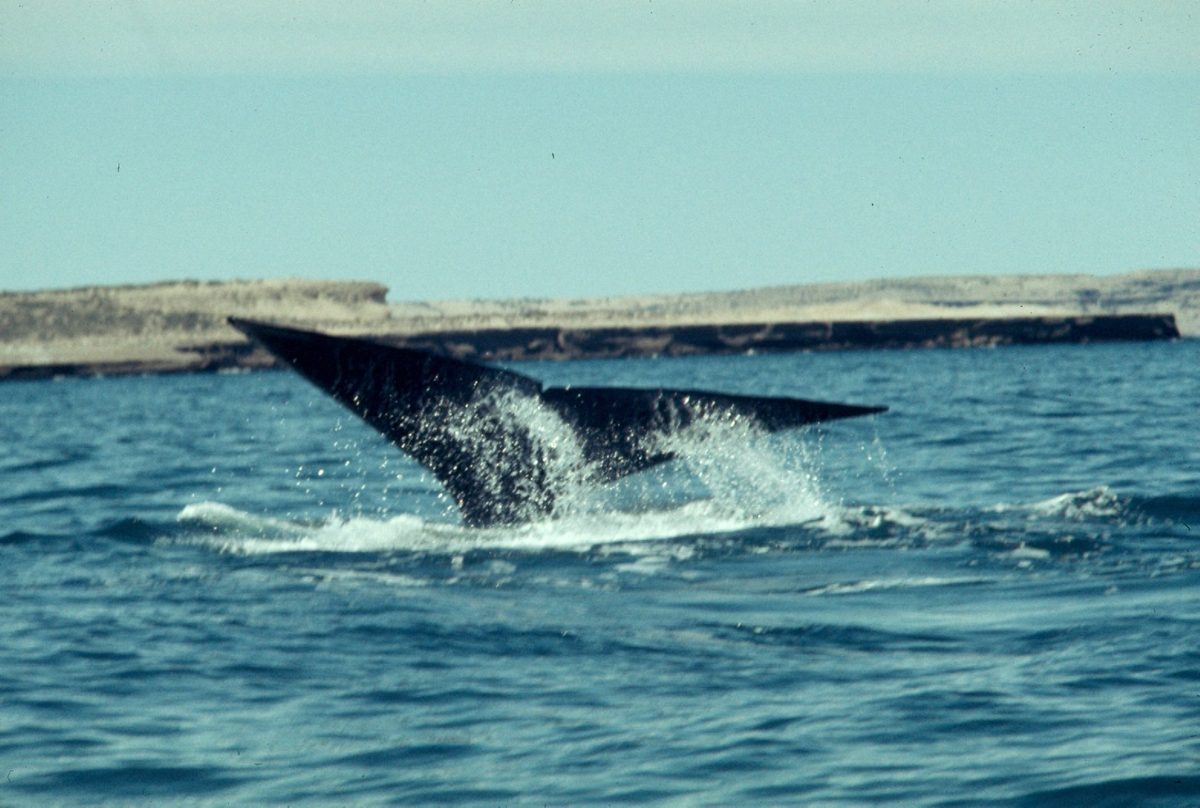
This is, for my money, Uruguay’s best wildlife experience, and the part the listicles undersell because it doesn’t fit a “national park” box. Every year from roughly July to November, with the peak around September and October, southern right whales migrate up from the Southern Ocean to calve and court in the calm bays off Uruguay’s Atlantic coast. These are enormous animals — adults run to 16 metres and 40-odd tonnes — and the wonderful thing is that you watch them for free, from dry land, often close enough to see the calves roll.
You don’t need a boat. The clifftops and headlands of Rocha and Maldonado are natural grandstands. My go-to spots: the Cerro de la Virgen viewpoint at La Paloma, the lighthouse at José Ignacio, La Pedrera, the rocks at Cabo Polonio and Cerro Verde, and Playa Mansa in Punta del Este. Bring binoculars, scan the swell for the V-shaped blow, and be patient — once you spot one, you’ll see it surface again and again. There’s even a designated “whale route” (Ruta de la Ballena) along the coast.
Because the season falls in the cooler months, whale watching is the centrepiece of the argument for visiting Uruguay out of summer; I make that case in detail in the best time to visit Uruguay guide. Pack a windproof layer — the coast is bracing in August — and check local sighting reports, which spread fast on regional tourism channels.
Birdwatching in Uruguay
For a small country with no mountains or rainforest, Uruguay punches well above its weight for birds — well over 400 species have been recorded, thanks to the meeting of grassland, wetland, coast and subtropical influences. You don’t need to be a hardcore birder to enjoy it; the spectacle is accessible and the backdrops are beautiful.
The coastal lagoons are the headline. Laguna de Rocha and Laguna Garzón draw flamingos, black-necked swans, coscoroba swans, herons, spoonbills and clouds of migratory shorebirds. The Esteros de Farrapos wetlands on the Río Uruguay add storks, kingfishers and raptors, while the northern valleys of Lunarejo bring in subtropical species you won’t find further south. Even the grassland delivers — rheas, the southern lapwing (tero), burrowing owls on fence posts, and the ubiquitous hornero. Spring (September to November) is prime time, when residents are nesting and migrants pass through. A decent pair of binoculars and an early start are all the equipment you really need.
Hiking & the Outdoors
Uruguay isn’t a trekking destination in the alpine sense — there are few long, way-marked trails and no high-altitude routes. What it offers instead is gentle, scenic day-walking, and a culture of getting outdoors that revolves around horses, fishing, cycling and the asado at the end. The best genuine hikes are the canyon loop at Quebrada de los Cuervos, the climbs up Cerro Arequita, Cerro Pan de Azúcar and the Sierra de las Ánimas, and the forest tracks of Santa Teresa. For something different, many estancias (ranches) open their gates to visitors for horseback riding across country you could never reach on foot — a quintessentially Uruguayan way to see the land.
Cycling is big too: the flat-to-rolling terrain and quiet roads suit touring, and the coastal route between the Rocha beaches is a joy on two wheels in the shoulder seasons. Sea kayaking on the lagoons and the Río Uruguay rounds out the menu. None of it is extreme; all of it is pleasant.
Planning Your Visit
When to Go
Season changes everything here. Summer (December–February) brings hot, beach-perfect weather but also crowds and peak prices at the coastal parks; Cabo Polonio and Santa Teresa are at their busiest in January. Spring (September–November) is my favourite for nature — mild days, nesting birds, wildflowers, and the tail of whale season. Autumn (March–May) is quiet and golden. Winter (June–August) is cool and can be wet, but it’s prime whale-watching time and the parks are blissfully empty. There’s a fuller breakdown in our month-by-month guide.
Getting Around
The single most useful thing I can tell you: rent a car. Buses connect the towns, but almost every protected area sits down a side road or gravel track that public transport doesn’t serve, and the freedom to stop for a roadside capybara or a lagoon full of flamingos is the whole point. Roads are generally good, distances are short by South American standards, and fuel is widely available — though fill up before long rural stretches. Our getting around Uruguay guide covers car hire, ferries from Buenos Aires and the practicalities.
Fees, Camping & What to Bring
Most parks are free; where there’s a charge — the Santa Teresa fort, Quebrada de los Cuervos, Cerro Arequita — it’s small, and often cash-only, so carry pesos. Camping is the classic way to stay in the bigger parks, with Santa Teresa’s vast campground the obvious example; book ahead for January. Bring sun protection (the ozone-thin southern sun is fierce), insect repellent for the wetlands, layers for the wind, plenty of water, and a head torch if you’re staying at off-grid Cabo Polonio. Cell coverage drops out in the remoter areas, so download maps offline. For broader logistics — money, safety, language, tipping — see our Uruguay travel tips.
Is It Safe?
The natural hazards are mild: strong rip currents on the open Atlantic beaches (swim where locals do), the fierce sun, and ticks in long grass. There are no large predators and the only venomous snakes — a couple of pit viper species — are shy and rarely encountered if you watch where you put your hands and feet. The parks themselves are very safe; the usual small-town common sense is all you need.
The Parks by Traveler Type
Families: Santa Teresa is the easy winner — a fort kids can clamber over, safe forest trails, beaches and a campground built for family holidays. San Miguel adds capybaras and farm animals.
Couples & slow travellers: an off-grid night at Cabo Polonio, or a hillside cabin near Villa Serrana with a valley view and a wood fire. Quiet, romantic, unplugged.
Wildlife & birders: the Rocha lagoons for flamingos and swans, the coast in winter for whales, Esteros de Farrapos for wetland birds, and San Miguel for grassland species. Bring binoculars and patience.
Hikers & active travellers: Quebrada de los Cuervos for the best canyon walk, the Lavalleja and Maldonado hills for climbs, and an estancia stay for riding. Pair it with a cross-country Uruguay itinerary.
Campers & road-trippers: base yourself in Rocha, pitch at Santa Teresa, and use the car to hop between dunes, forts and lagoons over three or four unhurried days.
Uruguay National Parks: FAQ
Does Uruguay have national parks?
Yes. Uruguay protects its wild places through SNAP, the National System of Protected Areas, which includes formal national parks such as Cabo Polonio and Esteros de Farrapos alongside protected landscapes, natural monuments and reserves. They’re smaller and less developed than parks in neighbouring countries, but there are more than twenty of them spread across the country.
What is the most famous national park in Uruguay?
Cabo Polonio is the best known — an off-grid dune village and national park in Rocha with a major sea lion colony, reached only by 4×4 across the sand. Santa Teresa, with its 18th-century fortress, forest and beaches, runs a close second and is the easiest to visit by car.
How many national parks does Uruguay have?
It depends how you count. Only a handful carry the formal “national park” label, but the wider SNAP system protects more than twenty areas in several categories. For trip-planning, focus less on the label and more on the experience — coast, canyon, wetland or hills — which is how this guide is organised.
Are Uruguay’s national parks free to enter?
Most are free, which is part of their charm. A few charge a small fee — the Santa Teresa fortress, Quebrada de los Cuervos and Cerro Arequita — usually payable in cash. At Cabo Polonio the park is free but you pay for the 4×4 transport, and camping anywhere requires a separate, modest fee.
Where can you see wildlife in Uruguay?
Head east. The Rocha lagoons deliver flamingos and swans, Cabo Polonio and Isla de Lobos have sea lions, and San Miguel and the eastern wetlands are best for capybaras, rheas and pampas deer. From July to November, southern right whales can be watched for free from the coastal clifftops of Rocha and Maldonado.
When is the best time to visit Uruguay’s parks?
Spring (September–November) is ideal: mild weather, nesting birds and the end of whale season, without summer’s crowds. Summer is best for beach camping but busy and pricey. Winter is quiet and cool but prime for whales. Autumn is golden and calm. Match the season to what you’re after: empty beaches, wildlife, or pure solitude.
Final Thoughts
Uruguay rewards travellers who slow down, and nowhere more than in its protected areas. You won’t tick off famous peaks or vast wilderness; you’ll get a sea lion colony you can almost touch, a fort with horses grazing in its shadow, a canyon full of birdsong, and whales rolling offshore while you stand on a clifftop with a thermos of mate. It’s nature on a human, unhurried scale — and after years of coming back, that’s exactly why I keep returning. Pick a region, rent a car, leave time to get a little lost, and let the country’s quiet wild side find you.
Credits & sources
Sources & Further Reading
- Ministerio de Ambiente — Sistema Nacional de Áreas Protegidas (SNAP)
- Uruguay Natural — official national tourism board
- The Ramsar Convention on Wetlands (Esteros de Farrapos, Bañados del Este)
Photo Credits
- Cabo Polonio lighthouse at dusk — Julio Clavijo Ferraro / CC BY-SA 4.0 via Wikimedia Commons
- Fortaleza de Santa Teresa — Roxyuru / CC BY-SA 3.0 via Wikimedia Commons
- Sea lions at Cabo Polonio — Kenspuss / CC BY-SA 3.0 via Wikimedia Commons
- Quebrada de los Cuervos boardwalk — Caritocabrera / CC BY-SA 3.0 via Wikimedia Commons
- Capybaras in Uruguay — Enrique González / CC BY-SA 4.0 via Wikimedia Commons
- Southern right whale — Warren Garst / CC BY-SA 4.0 via Wikimedia Commons
- Cerro Arequita — Marcelo Campi / CC BY-SA 2.0 via Wikimedia Commons
- Laguna de Rocha — Casaseneleste / CC BY-SA 3.0 via Wikimedia Commons
About Uruguay Tourism Guide
Uruguay Tourism Guide is an independent travel resource written from first-hand research on the ground in Uruguay — driving the back roads, walking the trails and camping in the parks described here. We don’t take payment for coverage, and we flag honest drawbacks alongside the highlights. Prices, hours and access can change, so treat specifics as a starting point and confirm current details before you travel. Last updated: June 2026.
1 comment
Comments are closed.