Atlantida & the Costa de Oro: Montevideo’s Local Beaches (2026)

The first time I drove out to Atlántida, I almost missed the turn. A small sign on the Interbalnearia points to “El Águila,” and I followed it on a hunch, down to the water. What I found was a giant stone eagle head staring out over the river, a beach so wide it felt unreal for a Saturday, and families drinking mate (the bitter herbal tea that is practically a national handshake here) on the sand. No crowds, no hawkers. I have gone back every summer since.
This is Atlantida Uruguay, and the Costa de Oro around it is the coast Montevideo quietly keeps for itself.
Atlantida Uruguay is a quiet, pine-backed beach town about 45 to 50 kilometres east of Montevideo, the unofficial capital of the Costa de Oro string of balnearios. It is famous for two oddities, the El Águila eagle folly and Eladio Dieste’s UNESCO-listed brick church, plus long, calm, family beaches that fill up only on summer weekends.
If your image of the Uruguayan coast is the glass towers of Punta del Este’s high-rise glamour, this is the opposite. It is unhurried, a little faded in the best way, and built around the rhythms of local family holidays rather than international tourism. Balneario, by the way, just means a small seaside resort town, and the Costa de Oro has dozens of them strung along the shore like beads.
What this guide covers
I am going to walk you through Atlántida as the anchor town, then the whole Costa de Oro corridor that runs east from the edge of Montevideo, the balnearios of Salinas, Marindia, El Pinar, La Floresta, Cuchilla Alta and Jaureguiberry. We will cover the eagle, the Dieste church in real detail, the beaches, how Uruguayans actually use this coast, how to get here, and who it suits (and who it does not). I will also flag the one honest drawback of each thing, because a place this gentle deserves honest treatment.
What I am deliberately not doing is doubling up on neighbours. For the next resort east, with its hills and funicular, see my separate guide to Piriápolis. For the city sands right in the capital, the Montevideo rambla beaches get their own write-up (a rambla is the waterfront promenade that runs along the coast). And this whole piece sits under my larger guide to the best beaches in Uruguay if you want the national picture first.
| Detail | What to know |
|---|---|
| Where | Canelones department, Río de la Plata coast, east of Ciudad de la Costa |
| Distance from Montevideo | ~45–50 km; roughly 50–60 min by car, under an hour |
| Distance from Carrasco Airport | ~20 km (around 25 min) |
| Anchor town | Atlántida (founded 1911, the “tourist capital” of the coast) |
| The two beaches | La Mansa (calm, family) and La Brava (waves, surf-leaning) |
| Must-see oddity | El Águila, a stone eagle-head folly on the shore, built 1945 |
| UNESCO site | Iglesia del Cristo Obrero by Eladio Dieste (designed 1958, opened 1960, listed 2021) |
| Best for | Families, slow travellers, day trips, architecture pilgrims, off-season walkers |
| Less good for | Nightlife seekers, luxury hunters, anyone wanting big-resort polish |
| Peak season | December–February (Uruguayan summer); near-empty the rest of the year |
Atlantida Uruguay: the anchor town
Atlántida was founded in 1911, which by Uruguayan beach standards makes it ancient. Montevideo families came out here to build summer houses when the rest of the coast was still dunes and scrub, and that DNA never left. The town has actual shops, a couple of banks, a casino, bakeries, and enough year-round residents that it does not shut down entirely in winter. It feels like a small town that happens to sit on a beach, rather than a resort that empties to a ghost town in March.
The look is pines and eucalyptus running almost down to the sand, low houses, and streets that go quiet by mid-evening. People rent houses by the week or the fortnight rather than booking hotels, which tells you everything about the pace. You come here to do very little, on purpose. If you want a sense of how this fits a wider trip, my guide to things to do across Uruguay sets Atlántida against the busier options.
La Mansa and La Brava: the two beaches
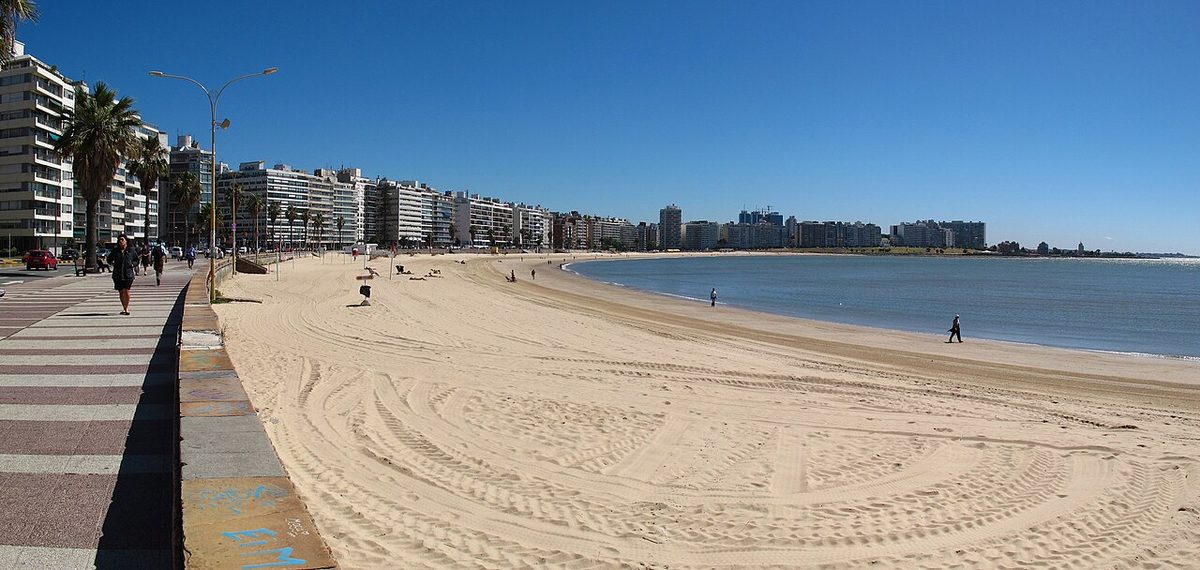
Atlántida has two main beaches, and their names tell you exactly what you are getting. La Mansa (“the calm one”) faces the more sheltered water and is where families plant their umbrellas, because the shallows stay gentle and the waves are usually mild. It is genuinely good for small kids. La Brava (“the rough one”), around the headland, catches more swell and pulls in the teenagers, the bodyboarders and anyone who wants the water to feel more like ocean than river. It is a forgiving place to take a first lesson, though the real Atlantic swell starts further east; my rundown of Uruguay’s surf spots and seasons explains where and when.
A quick geography note that confuses first-timers: this is technically still the Río de la Plata, the enormous river estuary, not the open Atlantic. Uruguayans cheerfully call it “el mar” (the sea) anyway, and honestly it looks, smells and behaves like the sea most days. The water tends blue-green and turns properly ocean-coloured the further east you drive.
The sand itself is the draw, pale, fine and very wide, backed by pine. Even at the height of January, when the central beach in front of town gets busy, you only have to walk fifteen minutes in either direction to have a long stretch nearly to yourself. The honest drawback: because this is estuary water, there are days when the river runs brown and silty after rain or a strong south wind, and it is not always the postcard turquoise. Check the sky before you commit your whole day to swimming.

El Águila: the eagle that nobody can quite explain
West along the shore, in the Villa Argentina section, sits one of the strangest sights on the Uruguayan coast. El Águila is a giant eagle head, maybe two storeys tall, made of stone and cement, perched on the embankment and glaring out at the water. It was built in 1945, and the wonderful thing is that nobody can fully agree on why.
The most repeated story is that it was a folly attached to a private property, possibly a tea-house or a viewpoint, possibly a smuggler’s lookout, possibly just one wealthy eccentric’s whim. Locals also call it “La Quimera” (the chimera). There is no plaque with a tidy answer, and that is half the charm. You climb up, you look at this fierce stone bird, and you make up your own legend. Kids love it.

It is also the best free viewpoint in town, a clean line down the coast in both directions. The drawback is simply that it is small, you will spend maybe twenty minutes here, photos included, so treat it as a stop on a beach walk rather than a destination in itself. If you are driving, follow the “Águila” sign off the highway before the main Atlántida exit, and park on the coastal road.
El Planeta and the old summer-resort bones
Back in town, look for El Planeta, a curved 1937 building that was once a glamorous hotel hosting Argentine high society and is now a National Historical Monument. You cannot tour it like a museum, but its lines tell you that Atlántida was, briefly, a fashionable address before fashion moved east to Punta del Este. That faded-grandeur quality runs through the whole place, and I find it more moving than any polished resort.
The Cristo Obrero church: Atlántida’s UNESCO masterpiece
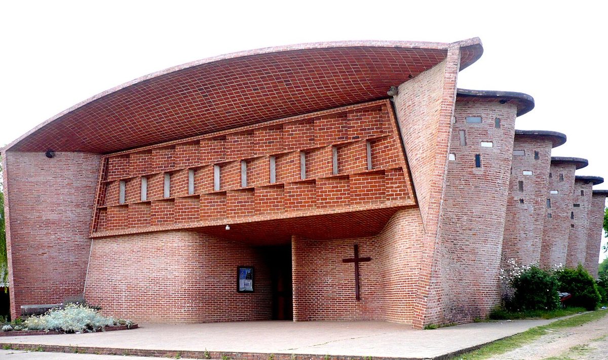
Cross to the inland side of the highway, into the humble village of Estación Atlántida, and you reach the reason architects fly to this otherwise sleepy stretch of coast. The Iglesia del Cristo Obrero y Nuestra Señora de Lourdes, the Church of Christ the Worker, is one of the most quietly astonishing buildings I have stood inside anywhere.
It was designed in 1958 by Eladio Dieste, a Uruguayan engineer rather than a celebrity architect, and opened in 1960. In 2021 UNESCO inscribed it on the World Heritage List under the formal title “The work of engineer Eladio Dieste: Church of Atlántida.” That makes it one of the country’s flagship cultural sites, and it sits comfortably alongside the rest of the nation’s heritage in my overview of Uruguay’s UNESCO sites.
Why this brick building is a big deal
From the road it can look almost plain, a long brick box. Then you notice the walls are not straight. They ripple, rising and falling in undulating curves, and the roof does the same in waves overhead. There is not a single internal column or supporting beam. The whole space is held up by the geometry of the brick itself.
Dieste called his method “reinforced ceramics,” and he was a master of it, so much so that his peers nicknamed him the master of brick. Instead of pouring concrete or raising steel, he used thin curved shells of ordinary brick, shaped into what engineers call Gaussian vaults, to span the room. His guiding principle was “the strength of forms, not the redundant accumulation of material.” In plain terms, he made cheap, humble brick do the work of expensive engineering, through shape alone. The side walls are double-skinned and rise to about seven metres; the vaulted roof spans up to nearly nineteen metres unsupported.
Step inside on a sunny day and the brick glows warm orange, light filtering through small coloured glazing, the curves drawing your eye up and along. It is humble and soaring at the same time. The detached cylindrical bell tower, built in openwork brick so you can see daylight through the lattice, stands to the right of the facade. Do not miss the underground baptistery on the left, reached through a sharp triangular entrance and lit by a single round oculus from above. It is theatrical in a way the rest of the building never shouts about.
The point Dieste was making
Here is the detail that gives me chills every time. Dieste built this extraordinary church not in glamorous Atlántida proper, but across the highway in Estación Atlántida, a poor working village. The choice was deliberate. The church is dedicated to Christ the Worker, and Dieste, a devout man, wanted to prove that real beauty and dignity belonged to ordinary people, built from the cheapest material there is. UNESCO’s citation leans on exactly this, modern architecture in service of social equality, achieved with a spare use of resources. Knowing that, the building hits very differently.
Visiting the church: the practical bit
The church is a working parish, so opening hours revolve around mass and can be irregular; mornings are usually your safest bet, and there is sometimes a small suggested donation for upkeep, around a few dollars last I checked. It is roughly a ten-minute drive inland from Atlántida’s beach, signposted off Route 11. If you are relying on buses it is more awkward to reach than the beach, which is the honest drawback, so this is one attraction where having a car, or building it into a wider day trip out of Montevideo, pays off. Photography inside is usually allowed; just be respectful if a service is on.
The Costa de Oro corridor: a tour of the balnearios
Atlántida is the anchor, but it is really one link in a chain. The Costa de Oro (“Gold Coast”) runs for around 70 kilometres through Canelones department, roughly thirty small seaside settlements strung between the rivers just east of Montevideo’s airport and the Solís Grande, which marks the border with Maldonado. The further east you go, the wilder it gets, the bigger the waves, the scrubbier the land, the fewer the people. Here is how the string runs, west to east.
Salinas and Marindia: the western end
The town of Salinas sits at around kilometre 39 of the Interbalnearia, one of the first proper balnearios you hit heading out from the city. It has a long, broad beach and a slightly busier, more built-up feel than the towns further east, because it is close enough to Montevideo to be almost a commuter-belt beach. Marindia, just beyond, is quieter and more bohemian, the kind of place with a low-key arty crowd and good empty sand. Both are easy first stops if you only have an afternoon.
El Pinar: pines and dunes
Technically at the Ciudad de la Costa end, El Pinar takes its name from its four kilometres of pine-fringed beach, which throw welcome shade if you sit back from the waterline. The dunes here are a hit with kids, who sandboard down them, and there is a decent run of restaurants. It is the most suburban-feeling stop, closest to the city, but the beach itself is genuinely good. Carry on west from here and the pines give way to Carrasco, the first of Montevideo’s own city beaches, which run along the rambla all the way to Parque Rodó.

La Floresta: the grande dame
Here you reach La Floresta, the oldest resort on the coast, named for the company that planted a million trees on these dunes in the early 1900s. Like Atlántida it is an established, generational sort of place, families have held the same holiday houses for decades, and it has some of the best beaches on the Costa de Oro. In summer the town runs family-friendly cultural events, including a “Noche Blanca” (White Night) timed to a full moon. It has just enough infrastructure to be comfortable and not an ounce more.

Parque del Plata, Costa Azul and San Luis
Between Atlántida and La Floresta, Parque del Plata spreads along about four kilometres of dune-backed beach, with a sheltered sandbar at the mouth of the Solís Chico river that is popular for fishing and small boats. Keep going and you reach Costa Azul, then San Luis, one of the least developed pockets of the whole coast, all quiet sand and native forest, where locals fish the shallows at night by flashlight, a practice they call “pesca a la encandilada.”
Cuchilla Alta and Jaureguiberry: the wild east
By the time you reach Cuchilla Alta the coast has turned distinctly more oceanic, bigger waves, rockier headlands, options for boat fishing and water sports. The little island of La Tuna sits offshore. Then comes Jaureguiberry (roughly “how-reg-ee-BERRY,” and yes, everyone struggles with it), the last beach on the Costa de Oro before the river Solís Grande. It has dramatic dunes, the hills of Piriápolis on the horizon, and a genuine claim to fame: the first fully off-grid public school in Latin America, built from 2,000 tyres, thousands of bottles and cans, visible from the highway just before the bridge.
The thing that ties them all together
What every one of these towns shares is a nostalgic, almost 1950s summer feeling, calm safe water for children, sand as fine as sugar, and parking that is never a problem. Most of the tourists you will meet are Uruguayan, which is exactly why the coast has stayed unspoiled. Foreign visitors mostly blow straight past on the highway to the bright lights of Punta del Este, and the locals are quietly happy to keep it that way.
How Uruguayans actually use the Costa de Oro
To understand this coast you have to understand that for Montevideanos it is not really “travel.” It is the family beach, the place you have been going since you were a kid, the house your grandparents bought. That shapes everything about the experience, and it is the whole reason it feels so different from a resort built for outsiders.
Days here run on a simple loop. People arrive at the beach late morning, set up under a pine, and settle in for hours with a thermos and a mate gourd passed around the circle. Lunch is often grilled, the parrilla (a wood or charcoal barbecue grill, and the social ritual built around it) being close to sacred in Uruguay. Late afternoon, families drift down to the rambla, the paved waterfront walk, for an ice cream and a stroll as the light goes gold. Evenings are low-key, dinner at home in the rented house, maybe a wander into town. There is very little nightlife, and that is the point, not a failing.
If you want to eat out, the towns have solid, unfussy parrillas and pizza places rather than destination restaurants, though Canelones as a whole has quietly become a good food region thanks to its farms. Order a chivito (Uruguay’s gloriously overloaded steak sandwich) at least once. For a fuller sense of the local table, my notes on things to do and eat in Uruguay go deeper.
Getting to Atlántida and the Costa de Oro
This coast is genuinely easy to reach, which is its great advantage over the more famous beaches further east.
By car is the way I always recommend, because it unlocks the whole string of balnearios and the inland church in one trip. From central Montevideo, take the Rambla east, join the Ruta Interbalnearia, and Atlántida is about 45 to 50 kilometres on, well under an hour in normal traffic. The balnearios are signposted by their kilometre markers (Salinas around km 39, others following east), so you can hop off wherever the mood takes you. For wider arrival logistics, see my guide to getting to Uruguay.
From Carrasco International Airport you are only about 20 kilometres away, roughly 25 minutes, which means you can land and be on the sand before lunch. That proximity makes the Costa de Oro a smart first or last night of a trip.
By bus is very doable for Atlántida and the bigger towns. Frequent intercity buses leave from Montevideo’s Río Branco terminal and the main Tres Cruces bus station, and the ride takes around an hour. The honest drawback of going bus-only is that the Dieste church and the smaller eastern balnearios are awkward without wheels, so buses suit a beach day in town more than a roaming coastal tour.
Who the Costa de Oro suits (and who it does not)
Let me be blunt, because matching the place to the person matters more here than almost anywhere on the Uruguayan coast.
You will love this coast if you are travelling with children (the calm Mansa-style water is hard to beat, and my Uruguay with kids guide leans on exactly these beaches), if you want a slow, do-nothing few days, if you are an architecture lover making a pilgrimage to Dieste, or if you are visiting off-season and want long empty beaches to walk. It is also ideal for a day trip if you are based in the capital, a point I make in my Montevideo city guide.
Where this coast falls short is for a different traveller. Expect to be disappointed if you want nightlife, fine dining, luxury hotels, or the see-and-be-seen energy of a big resort. There is none of that here, by design. For polish and a party, drive the extra hour east. For peace, you have already arrived.
On timing, this is overwhelmingly a December-to-February proposition for swimming and atmosphere; my best time to visit Uruguay breakdown explains the trade-offs, but in short, summer for the buzz, shoulder season for solitude, winter for moody empty walks. If you need a base with more amenities, weigh up your options in my where to stay in Uruguay guide.
Atlantida Uruguay: your questions answered
Is Atlántida Uruguay worth visiting?
Yes, if you want a calm, authentic Uruguayan beach town rather than a polished international resort. Its draws are genuinely unusual: the El Águila eagle folly, Eladio Dieste’s UNESCO brick church just inland, and wide, family-friendly beaches that stay quiet outside summer weekends. Skip it only if nightlife and luxury are your priorities.
How far is Atlántida from Montevideo?
Atlántida sits about 45 to 50 kilometres east of central Montevideo, roughly 50 to 60 minutes by car along the Ruta Interbalnearia, comfortably under an hour. From Carrasco International Airport it is only around 20 kilometres, about 25 minutes, which makes it an easy first or last stop on a Uruguay trip.
What is the Cristo Obrero church in Atlántida?
It is the Church of Christ the Worker, designed by Uruguayan engineer Eladio Dieste in 1958 and opened in 1960, in the village of Estación Atlántida. Built entirely from undulating exposed brick with no internal columns, it became a UNESCO World Heritage Site in 2021 as a landmark of modern Latin American architecture.
Why was the El Águila eagle built in Atlántida?
Honestly, nobody knows for certain. The stone eagle head, also called La Quimera, was built in 1945, probably as a folly or viewpoint attached to a private property, with theories ranging from a tea-house to a smuggler’s lookout. There is no official explanation, which is exactly why it remains such a fun local talking point.
What is the difference between La Mansa and La Brava beaches?
The names say it all. La Mansa (“the calm one”) faces sheltered water with gentle shallows, ideal for families and small children. La Brava (“the rough one”), around the headland, catches more swell and suits bodyboarders and anyone wanting the water to feel like ocean. Most visitors use both depending on the day.
What is the best time to visit the Costa de Oro?
December to February is peak Uruguayan summer, with warm water, full beaches on weekends and the liveliest atmosphere. The shoulder seasons of spring and autumn give you mild weather and near-empty sand, my personal favourite. Winter is cold and quiet but wonderful for moody coastal walks if swimming is not the point.
Final thoughts
People ask me why I keep going back to a coast with no famous hotels, no scene and water that is technically a river. The answer is everything I have just described. The Costa de Oro is where Uruguay relaxes with its guard down, mate in hand, kids in the shallows, a stone eagle and a brick miracle of a church standing watch over it all. It is not trying to impress you, and that is precisely why it does.
Come for a day from Montevideo and you will get the eagle, a beach and the church. Come for a week, rent a house, learn the rhythm, and you will understand why Uruguayans guard this stretch of shore so quietly. Either way, you are seeing the real thing.
Credits & sources
Sources & further reading
- UNESCO World Heritage Centre, The work of engineer Eladio Dieste: Church of Atlántida
- Wikipedia, Iglesia de Cristo Obrero y Nuestra Señora de Lourdes
- Wikipedia, Costa de Oro (Uruguay)
- Uruguay Natural, official tourism board, Atlántida
Photo credits
All images via Wikimedia Commons: Atlantida Beach Uruguay by Andrés Franchi Ugart… (CC BY-SA 3.0); La Mansa Beach Atlantida by Andrés Franchi Ugart… (CC BY-SA 3.0); El Aguila Atlantida Eagle by Verónica González Abalos (CC BY-SA 3.0); Cristo Obrero Church Dieste by Andrés Franchi Ugart… (CC BY-SA 3.0); Costa De Oro Beach Uruguay by Andrés Franchi Ugart… (CC BY-SA 3.0); La Floresta Uruguay Beach by Eligna (CC BY-SA 4.0).